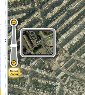
This nicely addresses a problem which has occurred in a few applications I've been involved with recently - how to communicate to the user what a given zoom level actually looks like.
At first I thought the control might be truly dynamic - i.e. pulling a live tile from the centre point of the current map view. But it's actually just a set of tile snippets at a fixed point. Still, it provides a very nice effect. (The dynamic version would be simple to implement, but perhaps would be too slow in actual use, with unpredicatable latency).
Are you listening, OpenLayers?
We had the dynamic version in an earlier copy of GeoTools (when the library was focused on applet development). We needed to remove it due to a patent on magnification tools ...
ReplyDeleteCool. I will use this idea in the software i3Geo.
ReplyDeleteSigh... is there no end to this rampaging patent craziness? Fie on it I say! Go Edmar! (and go OpenLayers!)
ReplyDeleteActually, Jody, I'm not sure your patent issue applies to this concept. The SuperZoom control isn't displaying a live magnified view - it's just displaying a set of predefined images which represent the different zoom levels. Hard to see how that could be patented.
ReplyDeleteYou are probably correct; your idea of being dynamic though is probably covered.
ReplyDelete