Monday, 14 May 2007

GeoTec 2007 presentation on Automated Watershed Boundary Generation

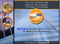
I'm giving a talk at GeoTec 2007 in Calgary entitled "WaterBuG: An Automated Generator for Watershed Boundaries". This covers a project I've been working on for the last year-and-a-half. It's a very cool application of complex large-scale geo-processing, using a whole assortment of nifty geometric structures and algorithms such as:
  • quad-edge subdivisions for modelling
  • Triangular Irregular Networks (Delaunay triangulations)Delaunay triangulation refinement
  • Medial axis refinement
  • Surface modelling with a TIN
  • Surface hydrological flow modelling over a TIN
  • Flood filling
  • Depth- and breadth-first Graph traversal
  • Topology-preserving Linestring smoothing
  • Discrepancy detection

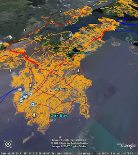
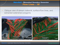
Here's a couple of screenshots from the talk - I'll post the full presentation sometime soon, somewhere...

Saturday, 12 May 2007

Whither Google Earth?

No question, GE has been wildly succesful. It pretty much single-handedly created the category of "spinny-globe" applications. As usual for Google, it redefined the parameters of what people thought the web was capable of doing (never mind that it was really Keyhole that did this, and skipping lightly over the fact that Google had to release a thick client app to achieve it). The bottom line is that GE has huge mindshare that competitors (WorldWind, MS Virtual Earth, ESRI ArcExplorer) are only just starting to nibble away at.

But can it last?

My prediction (and hope) is - No. Or at least, not in the same category-dominating way.

Reasons?

One is that the spinny globe paradigm is simply too fundamental to the way we want to interact with the virtual world to be left to a single company or application to dominate. Google/Keyhole proved the concept, but WorldWind shows that it can be done more generally and more openly - which in the end I believe has to win out.

Another is that as I've worked a bit more with GE and KML, I am astounded and annoyed by the numerous limitations of the data visualization options they provide. The simplest GIS viewer provides way better visualization options than GE (I know - I wrote one!). This isn't rocket science. My guess is that this reflects the fact that Google is not in the business of providing great visualization - they're in the business of selling ads. Which brings me to my next point...

It is probably contrary to Google's business model to enhance GE's capabilities too far. Make it more powerful and more configurable, and people start using it to do things which are just a distraction to the business of getting eyeballs on ads.

One possible opposing force to this thesis is the rising competition with other SG vendors (most notably of course MS). Perhaps this competition will force the evolution of greater functionality. But I'm not holding my breath - the other vendors all have their own business models which probably don't encourage loading functionality into the tools. The vendor with the most to gain from providing full-spectrum functionality is ESRI - but since they're really in the business of selling software, not data, my guess is that whatever they come up with is not going to be a real happy place to be for many users.

The one great hope IMO is WorldWind. They are ahead in some ways, behind in others, but they alone have no agenda other than making a really great SG application. I only hope they continue to thrive - although their dependence on the bureacratic whims of NASA makes me worry.

To go way out on a limb and look 20 yrs down the road, it may well be that spinny-globe access becomes much like topographic maps today - so essential to individual and business information that they (or at least the data repositories and protocols) are government-sponsored and freely available to all (ok, so topo maps aren't currently 100% free, but even here in behind-the-curve Canada more and more spatial data is being made freely available by Gov't). Maybe the SG app will just become a standard view in whatever is being used as a Web browser, with open formats and data models.

We can only hope...
Friday, 11 May 2007

Limitations of Google Earth as a GIS Viewer


I'm starting to actually try and used Google Earth for viewing geospatial data - and almost immediately I'm hitting my head against the ceiling. It seeems to be sorely missing some very basic GIS functionality (or else I'm not reading the manual closely enough - but the limitations of the "manual" also make my head hurt). Where are things like:

  • Line styles (dots and dashes?)
  • Labels for lines and polygons (Google roads get cool haloed rotated text - c'mon, I wanna play too!)
  • Tooltips for features
  • A decent zoom-to-feature
  • Decent rendering for polygonal outlines in oblique views (this is a weird one - the outlines seem to get more blocky as the viewpoint gets lower. Linear features render fine, so I presume this is some sort of artifact of a different display pipeline)
  • What's with defining colours as ABGR instead of the world-wide standard RGBA? Is someone at Google cixelsyd?
And in the bigger picture

  • No extensibility with custom add-ons
  • You can't change the terrain model (admittedly not everyone happens to have a DEM lying around - but I do, and I want to use it!)
I could go on and on.... but bottom line for me is that apart from the cool 3D stuff, GE sux for data visualization compared to the various OSS tools out there such as WorldWind and (ahem) JUMP.

They did get some stuff right though... The mouse navigation is good - although I think WorldWind's is better. WW's use of the right mouse button is way faster (for me) than using magic disappearing on-screen controls.

And of course KML has created an instant de-facto cartographic standard (I deliberately do not call it a geospatial data standard). Although it's pretty limited as well - SVG is way richer.

So I wonder if and when these shortcomings will be addressed? More on that later...

Getting in before it's over!

Not wanting to be the very last person in the world to be exposing their innermost secrets, I am finally getting around to staking my patch 'o turf in the blogosphere. Reason:

  • Gotta check out just how cool Google & Web 22.0 can make this experience (never mind that I hate the term Web 2.0 - that's a topic for another post)
  • Mucho cool stuff happening in the spatial world, which obviously needs me to comment on it
  • can't resist the challenge of coming up with a blog title that no-one else has. Took a couple of tries, but serendipity came to the rescue. Yeah it's syntax-geeky, but hey - that's what this blog is all about. Who was it who said "After syntax, all the rest is details"? Oh - it was me.